We develop and integrate unified control systems for drone inspection, linking docks, routes and missions with image capture, AI analysis, alarm dispatch and follow-up review. Functions and device compatibility are scoped per project.
To honor client confidentiality, related cases and scenes are anonymized. Client identities, locations, site imagery and client system screenshots are not shown. Images, videos and interfaces are illustrations of technical capabilities and applications, not client sites, measured system results or proof of project delivery. Maps, device identifiers and on-screen values are examples. Technical figures retain their stated sources, measurement methods and conditions; scope and acceptance criteria depend on site validation and project agreement.
Each mission links devices, routes, time windows and captured results.
Combining missions across scenarios or clients is assessed against permissions, payloads and flight conditions.
Schedule recurring and ad-hoc missions; check device status, payloads and flight windows
Plan routes by target and capture point; log mission execution and image capture
Edge or platform analysis per deployment; suspected anomalies go to human review
Link anomalies to asset records and work orders by business rules; interfaces scoped separately
Archive handling evidence and re-inspection results; used for model evaluation once authorized and quality-checked
A unified control architecture built around inspection missions, with interface development and business integration.
Compatible models, modules and integration scope are assessed by our technical team.

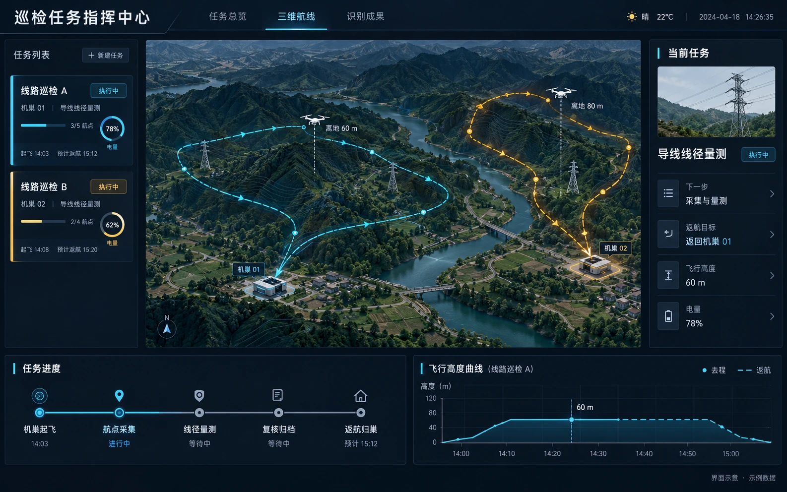
3D mission dispatch: docks, closed-loop routes and flight altitude (Chinese UI) · Illustration, sample data

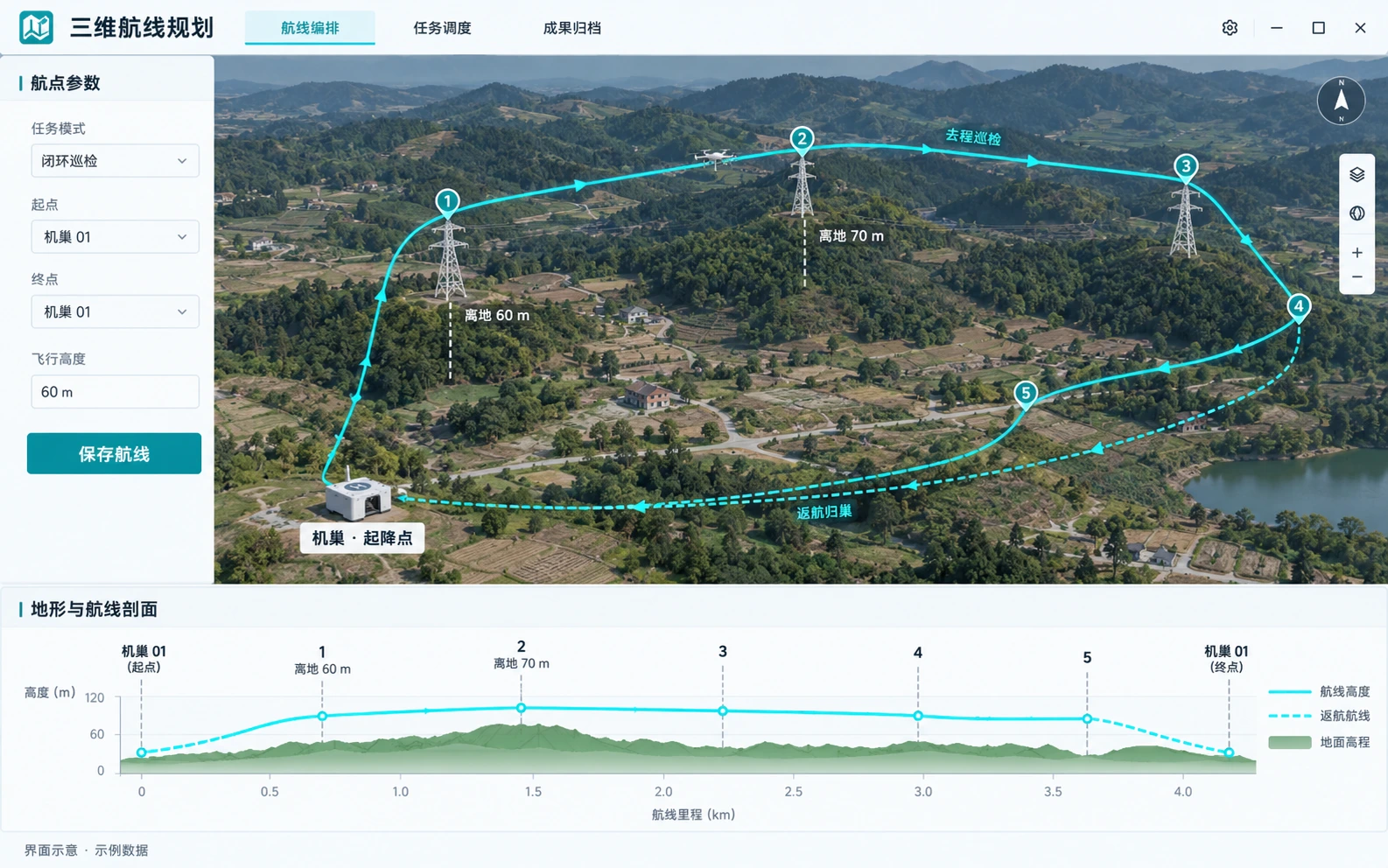
3D route planning: closed-loop inspection and return to dock (Chinese UI) · Illustration, sample data
Routes leave from a dock and return to the same dock after inspection; altitudes are example heights above ground. Actual routes must be checked for terrain, obstacles, endurance and return margin, with return-to-home settings configured to device capability.
Following the inspection workflow, we develop and integrate device access, route and mission management, flight monitoring and results archiving, with modules and interfaces configured per project.
Registration, status monitoring, remote operation and self-check for compatible devices
Waypoints, altitudes, capture points and recurring or ad-hoc missions on 3D terrain, configured per project
Work areas, geofences, plans and flight logs, scoped per project
Video link monitoring, manual takeover and return-to-home settings, subject to device and link conditions
Swap / charge status, cycle count, health and spare part alerts
Raw imagery and analysis archived by mission; backfill and distribution defined by the interface plan
Samples and evaluations are organized by line, season, lighting and target class. Human-reviewed data is used for iteration only after authorization, labeling and quality checks, and updates go live only after validation.
Defect detection, change detection, smoke and fire, behavior and event recognition
Point cloud clearance, crack dimensions, volume and area calculation
Alarm summaries, draft reports and procedure lookup from approved sources, reviewed by the business team
Edge or onboard deployment assessed by compute, model version and link; latency confirmed by testing
Delivered as subscribed scenario modules. Scenarios, modules and private deployment scope are set in the contract; ownership and use of training data are agreed separately.

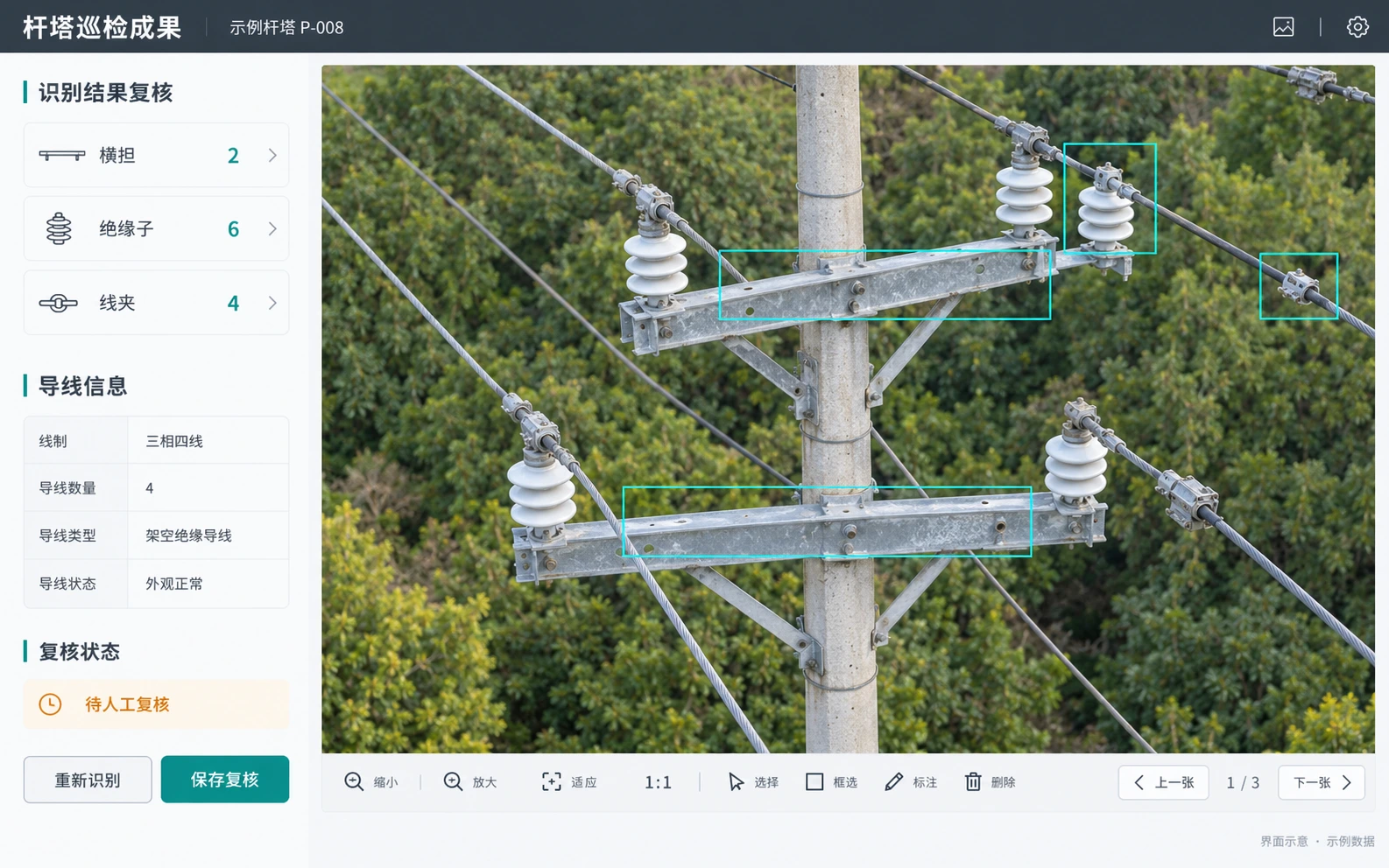
Tower recognition results with human review (Chinese UI) · Illustration, sample data
Scenario solutions organized by inspection target, capture method and deliverables.
Dispersed towers across mountains, river crossings and forests; components, corridor changes and review records must be linked.
Towers, fittings and insulators, conductors, corridorsModules and turbines are captured by asset ID, operating condition and inspection area, with suspected faults checked on site.
Modules and strings, inverters, blades and towersRiver sections, shorelines and levees need continuous segmented patrols with unified imagery, location and verification records.
Shorelines, levee hazard sections, intakes and outfallsAfter accidents or disasters, verifiable imagery is captured quickly and location and situation data provided to commanders.
Fires, hazmat incidents, flooding, landslidesLarge forests with varied terrain and coverage; suspected smoke, hot spots and land changes need re-capture and ground checks.
Forests and reserves, restoration areas, water sourcesSuspected new construction, bare land and facility issues spread across grids, linking discovery, dispatch and rectification checks.
Illegal construction, dust, street vending, municipal facilitiesBridge parts, high slopes and road sections are archived by component and segment for professional review.
Bridge structures and bearings, slopes, tunnel portalsPipeline corridors, stations and park facilities are patrolled by zone; construction changes and encroachment checked on site.
Pipeline corridors, valve stations, tank farms and flaresPlot and vegetation observations use consistent timing and boundaries, verified against ground samples.
Farmland and orchards, crop growth, disaster damageProgress comparison and volume calculation use a common survey area, coordinates and baseline, with versioned results.
Construction sites, cut and fill, stockpiles and spoil

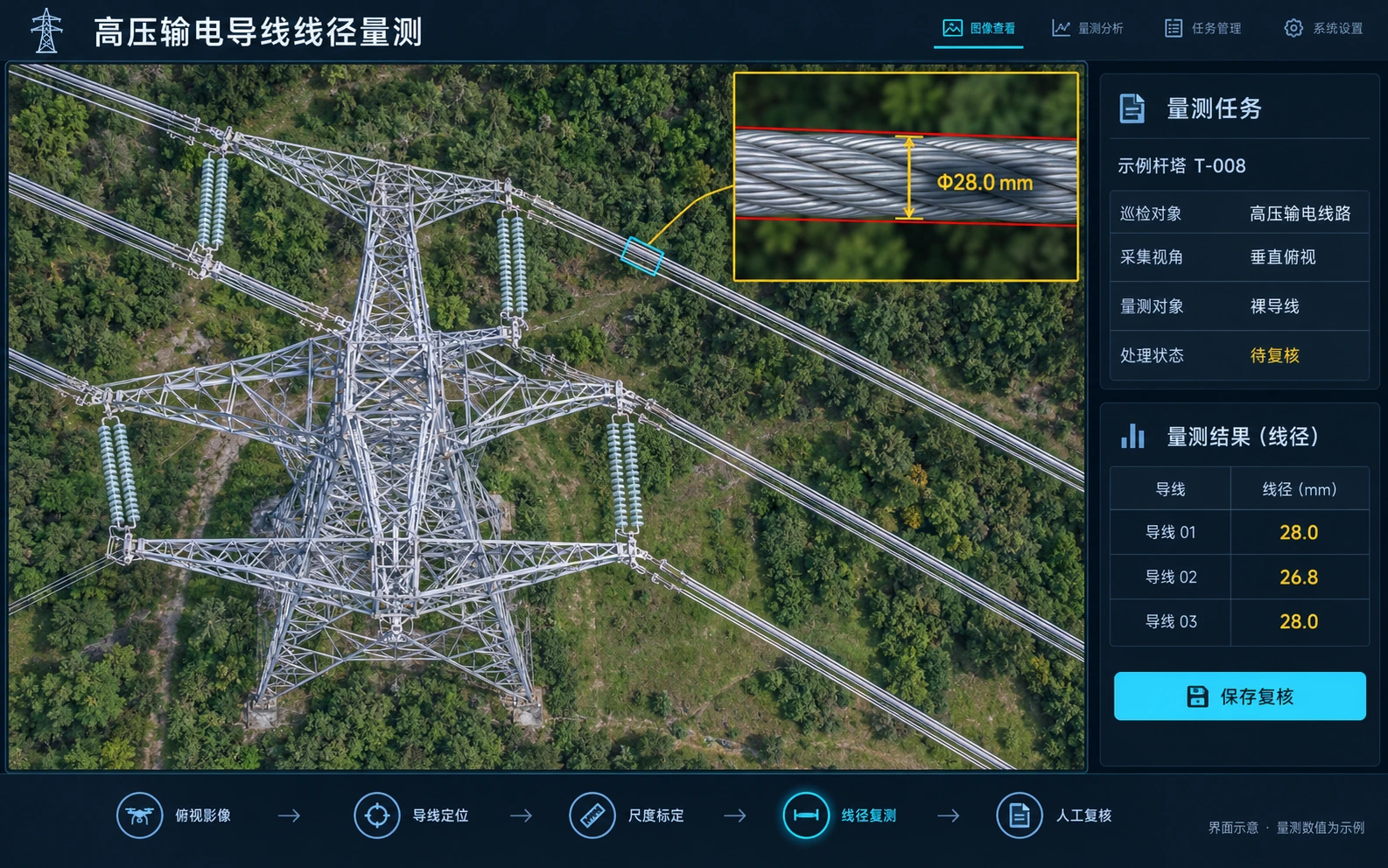
High-voltage conductor measurement · Top-down view · Illustration
A top-down view shows the tower crown, insulator strings and conductors. A magnified conductor region illustrates edge extraction, scale calibration and diameter measurement for human review.
Values shown are fictional examples. Accuracy for high-voltage tasks requires separate validation and does not inherit the low-voltage case figures below.

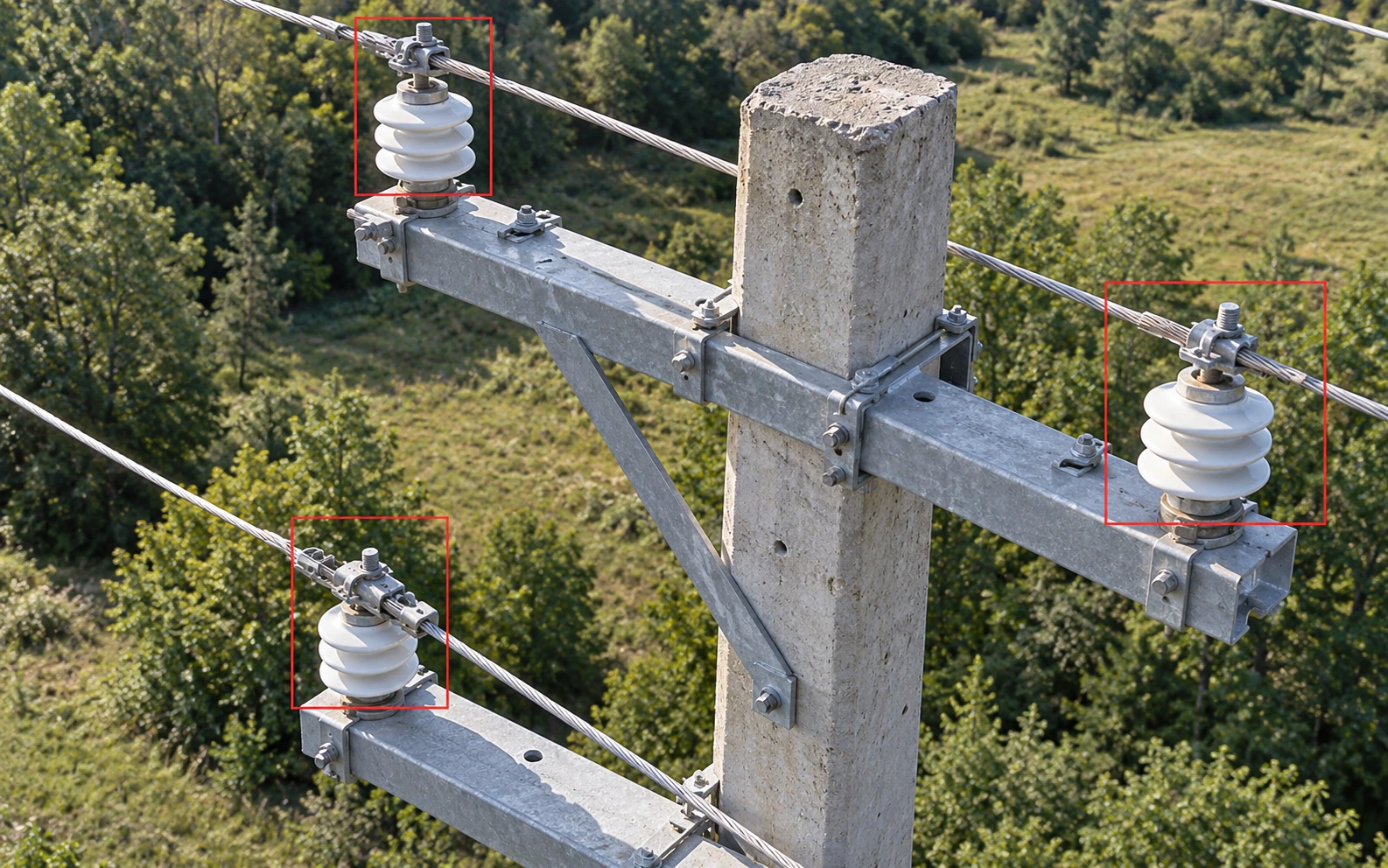
Tower fitting recognition: cross-arms, insulators, clamps, hanging plates · Illustration, sample data

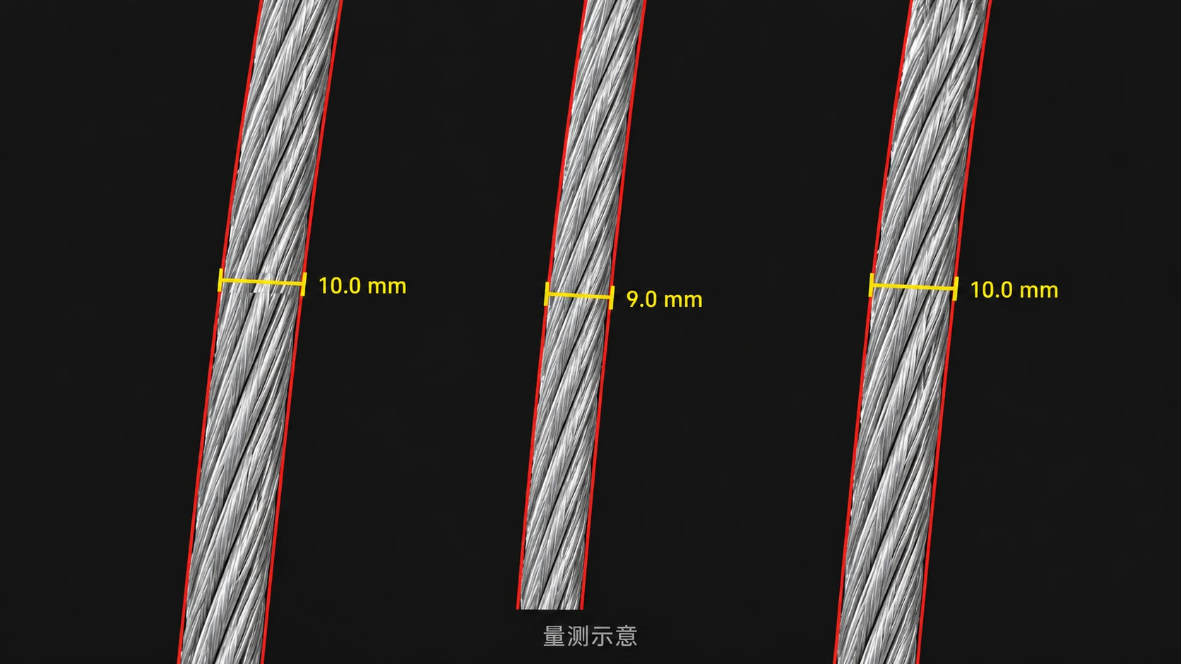
Conductor measurement task: calibration, measurement and review · Illustration, sample data
Drones capture tower-top imagery along planned routes, recording position and height, identifying conductor gauge, line configuration and fitting status, and building a distribution area map. Results are archived per tower with history and anomaly alerts.
Customer information is anonymized. Other scenarios require a new assessment of capture methods and algorithms.
Choose a model based on your existing equipment, inspection frequency and deliverables.
Maintenance responsibilities, bundled procurement, shared sites and settlement terms are agreed separately.
Dispatch, mission and results management for your own fleet
Equipment, platform and maintenance procured together
Inspection delivered to an agreed scope and deliverables
Start with a site assessment and a small pilot, then validate and expand in phases.
Confirm the first missions and validate device access, results review and settlement before assessing expansion.
Select the pilot city and 2–3 candidate sites; complete site surveys and airspace checks
Suggested: weeks 1–2Visit 2–3 target customers to confirm first scenarios, deliverable standards and willingness to pay
Suggested: weeks 2–4Agree site use, cost sharing, revenue split and regional scope
Suggested: weeks 4–5Build the first dock, open the platform and deliver the first inspection report for the agreed scenarios
Suggested: weeks 5–8First site built and first inspection report delivered
Assess more sites, mission volume and operating resources based on pilot results
Assess cross-region operating conditions, service organization and system support
The pace is a suggestion and can follow site availability and customer budget cycles. Keep Phase 1 small until procedures and airspace processes are in place.
Flight responsibilities, data management and security settings are defined in the proposal and contract.
Use of deliverables, access rights and management requirements are agreed per project.
Mission organization, operator and required approvals are confirmed per project; the platform supports mission records and documents.
Ownership and use of imagery, models and reports are set out in the contract; use of training samples is authorized separately.
Encryption, role permissions, masking, watermarking and audit are configured per project.
Purpose, quality requirements and responsible party for orthophotos, models and point clouds are confirmed, with qualifications verified by the project team.
Tell us about inspection targets, existing equipment, integration needs and deliverables so we can assess the scope of development and integration.
Please include the following in your email, and the relevant team will get back to you.